|
Walking on
Exmoor and the Quantock Hills |
||||||
|
|
|||||||
Menu
|
Exmoor and the Quantocks
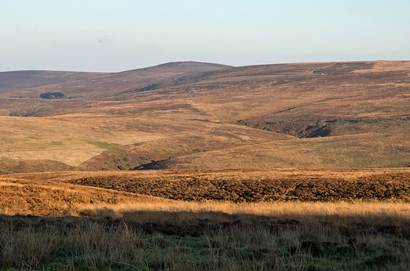
Dunkery Beacon from the Exford to
Porlock road Exmoor National
Park and the Quantock Hills are located in the south-west of England. Together with the far northern part of the
North Devon Coast they take up most of west Somerset and part of the far
north of Devon, stretching a little more than 45 miles east to west and
extending from the Bristol Channel to at most fifteen miles inland. They are in some senses off the beaten
track: no motorways run close by, they are not on the doorstep of any major
cities, and since the North Devon Link Road opened in 1988 they have been
bypassed by most of the summer traffic heading for coastal Devon and
Cornwall. They nevertheless make an
outstanding region for walking and exploring, and of all the protected areas
in Britain (Exmoor is one of England’s original National Parks and the
Quantocks and North Devon Coast are designated as National Landscapes) they
have some of the most varied countryside. The Exmoor
landscape is less stark and more diverse than the granite uplands that are
characteristic of Devon and Cornwall.
High moors, deep wooded combes, a dramatic coastline, rolling pasture,
babbling streams, lichen-clad and moss-draped Atlantic rainforest,
picture-postcard villages and even two sizeable lakes (albeit man-made) are
all within a short distance of each other.
This is prime walking country: there are enough paths, lanes, tracks
and bridleways, nearly a thousand miles in all, to keep the most dedicated
hiker busy for several months. There
are no mountains and only a few rocky crags and outcrops, but the attraction
is in the variation between open moors and dense woodland, secluded hamlets
and bustling villages, deep combes and towering cliffs - including one of the
most exhilarating and challenging sections of the South West Coast
Path. This site aims to
take the visitor (or the local who hasn’t explored the area on foot) to the
iconic and the less well-known places of Exmoor, the Quantocks and the North
Devon Coast. There are 100 main walks,
varying from easy 4- or 5-mile routes around locations such Bampton,
Parracombe and Clatworthy Reservoir, to more strenuous 10-12+ mile hikes over
the moors, down river valleys and along the coast. Many of the walks have shorter or longer
variations, so if you don't want to do a full day walk there are plenty of
gentler routes that delve into the depths of the countryside. On the other hand, routes can be linked
together to make energetic dawn-to-dusk hikes for long summer days, or
multiple-day routes making use of the many accommodation options in the
region.
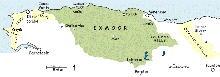
► Introduction to the region (pdf booklet) ► Map of the Exmoor and Quantocks
region with links to walks
All text, photographs and maps © Stan Lester 2024 |
||||||
|
|
|
||||||