|
Walking on
Exmoor and the Quantock Hills |
||||||
|
|
|||||||
Menu
|
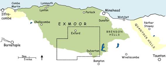
Central Exmoor: south of Winsford
This page covers
the inland area south from Exford and Winsford, down to Dulverton, Anstey
Moor and Molland. The area is
dominated by the rivers Barle and Exe and to a lesser extent Dane’s Brook,
all of which converge within a short distance of Dulverton, Exmoor’s historic
‘capital’ and an ideal walking base.
The landscape is a mix of open moorland and high grazing land broken
by the deep, often wooded river valleys.
The most popular walking area is the triangle between Dulverton,
Winsford and Exford, but the lesser-visited areas around Molland and the
Ansteys are no less interesting. A few
walks in this area cross open moorland without clear paths. Click the walk name
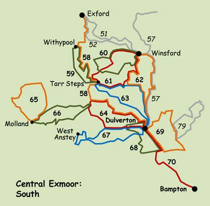
to download the route. Read the walk safety information, and click for a key to the symbols used on the sketch maps in the instructions. 57 Wheddon Cross to Dulverton via Winsford ♦♦♦ 10.5 mile linear, bus connection 58 Exford to Dulverton via
Withypool and Hawkridge ♦♦♦ 13 mile linear, bus connection 59 Withypool and Tarr Steps ♦♦ 7.3 mile circular 60 Winsford and around Winsford
Hill ♦♦ 8 mile circular 61 Winsford, Tarr Steps and the
Punchbowl ♦♦♦ 9.2 mile circular, short stretch of open moorland 62 Dulverton and Winsford ♦♦♦ 12.4 mile circular 63 Dulverton and Tarr Steps ♦♦♦ 10.7 mile circular 64 Dulverton, Hawkridge and the
River Barle ♦♦♦ 10.7 mile circular 65 Molland and Twitchen ♦♦ 7.7 mile circular, short stretch of open moorland 66 Molland and Anstey Common ♦♦♦ 8.5 mile circular, short stretch of open moorland 67 Dulverton, East and West
Anstey ♦♦♦ 10.8 mile circular 68 Dulverton, Brushford and
Chilcott ♦♦ 8.3 mile circular 69 Dulverton and Bury ♦♦♦ 9 mile circular 70 Dulverton to Bampton ♦♦ 6 mile linear, bus connection More walks from
Withypool in ‘Western Exmoor’,
and from Winsford in ‘Central Exmoor-North’.
All text, photographs and maps © Stan Lester 2025 |
||||||