|
Walking on
Exmoor and the Quantock Hills |
||||||
|
|
|||||||
Menu
|
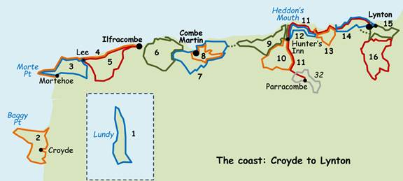
The North Devon coast: Croyde to Lynton
This page covers
the coastal area from Baggy Point to Lynton, including Lundy and part of the
North Devon Coast National Landscape. The
coast progresses from sweeping sandy bays through the jagged slates of Morte
Point, Bull Point and Ilfracombe to the massive sandstone hills east of Combe
Martin, including at Great Hangman the highest sea-cliffs in England. Highlights are almost too numerous to list
– they include Baggy Point, Morte Point, Lee Bay, Ilfracombe, Watermouth,
Berrynarbor, Heddon’s Mouth and the Valley of the Rocks. Walks range from moderate to strenuous, but
the reward is spectacular coastal scenery. Because of the
steep terrain several of the walks in this area are quite short: these are
arranged so that it is easy to combine them into longer walks (as long as you
are prepared for 1000+ metres of climb).
Click the walk name to download the route. Read the walk safety information, and click for a key to the symbols used on the sketch maps in the instructions. Note: ·
There have been
minor changes to the Coast Path at Combe Martin (walks
7 and 8) and either side of Lee Abbey (walks
11, 13 and 14). These don’t affect the
walks materially, but where I refer to the ‘Coast Path’ in the instructions
this may now be incorrect. ·
All-day parking in
many North Devon car parks is £10-15, particularly between March and November
(and all year in Lynton and Lynmouth) – please check parking fees here before
planning to use a particular car park.
1 Excursion to Lundy ♦♦♦ 9 or 6 mile
circular 2 Croyde,
Saunton Down and Baggy Point ♦♦ 8.5 mile circular 3 Mortehoe,
Morte Point and Lee Bay ♦♦♦ 7.2 mile
circular 4 Mortehoe to
Ilfracombe ♦♦♦ 7.7 mile linear, bus connection 5 Ilfracombe and Lee Bay
♦♦♦ 9.1 or 7 mile circular 6 Berrynarbor, Hele and
Watermouth ♦♦♦ 7.7 mile circular 7 Combe Martin, the Hangman
Hills and Berrynarbor ♦♦♦ 8 mile circular 8 Around Combe Martin ♦♦ 4.2 mile circular 9 Hunter’s Inn, Holdstone Down
and Heddon’s Mouth ♦♦♦! 9 mile circular 10 Hunter’s Inn, Voley and the
upper Heddon valley ♦♦ 5.8 mile circular 11 Parracombe to Lynton via the
Heddon Valley ♦♦♦! 9.5 mile linear, bus connection 12 Hunter’s Inn and Woody
Bay ♦♦♦! 6.8 mile circular 13 Lee Bay and Woody Bay ♦♦♦ 5.5 mile circular 14 Lynmouth, Lynton and the
Valley of the Rocks ♦♦♦ 5.6 mile circular 15 The East and West Lyn
gorges ♦♦♦ 5.4 mile circular 16 The Lyn hamlets, Barbrook and
Cheriton ♦♦! 6.1 or 7.5
mile circular
All text, photographs and maps © Stan Lester 2023 |
||||||