|
Walking on
Exmoor and the Quantock Hills |
||||||
|
|
|||||||
Menu
|
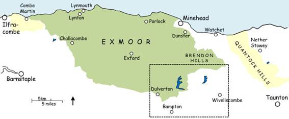
Bampton, Wiveliscombe and the lakes
This page covers
the southern part of the Brendon Hills, including Clatworthy Reservoir and
Wimbleball Lake, as well as the rolling country between Bampton and
Wiveliscombe. The landscape is
farmland, woods and streams with small villages and hamlets, often
attractive, interesting and off the beaten track. Walks are typically undulating rather than
particularly strenuous. Click the walk name
to download the route. Read the walk safety information, and click for a key to the symbols used on the sketch maps in the instructions. 79 Wimbleball, Bury and Haddon
Hill ♦♦ 7.6 mile circular 80 Wimbleball Lake ♦♦ 8.2 mile circular 81 The eastern side of
Wimbleball ♦♦ 6 mile circular 82 Bampton and Morebath ♦♦ 8 mile circular 83 Bampton and Cove ♦♦ 7.7 mile circular 84 Bampton and Clayhanger ♦♦♦ 11 or 7.5 mile circular 85 Waterrow, Clayhanger and
Raddington ♦♦♦ 9.7 mile circular 86 Wiveliscombe, Waterrow and
Hurstone Viaduct ♦♦♦ 9.1 or 7.5 mile circular 87 Wiveliscombe and Heydon Hill ♦♦♦ 8 mile circular 88 Wiveliscombe and Brompton
Ralph ♦♦ 8.3 mile circular 89 Clatworthy
Reservoir ♦ 5 mile circular
All text, photographs and maps © Stan Lester 2023 |
||||||