|
Walking on
Exmoor and the Quantock Hills |
||||||
|
|
|||||||
Menu
|
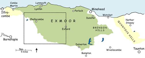
Western Exmoor
This page covers
the area to the west of Exford, including the former Royal Forest centred on
Simonsbath and the western fringes of inland Exmoor. The region includes archetypal Exmoor
landscapes of rounded hills, open moorland and hill-streams gathering their
strength. As well as classic moorland
walks from places such as Malmsmead, Simonsbath and Exford it includes some
lesser-visited areas on the fringes of the moor. Walks are not generally as strenuous as
might be imagined – the area is all fairly high-up – but some routes include
open moorland without well-defined paths, and the terrain can be hard going
particularly when the ground is waterlogged.
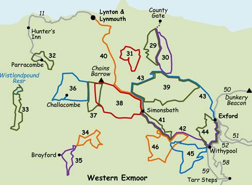
Click the walk name
to download the route. Read the walk safety information, and click for a key to the symbols used on the sketch maps in the instructions. 29 Malmsmead and Badgworthy ♦♦ 6.1 or 4.8 mile circular, moorland 30 Malmsmead, Great Tom’s Hill
and Oare ♦♦ 7.8 mile circular, moorland 31 Brendon Common ♦♦ 6 or 4.1 mile circular, moorland 32 Around Parracombe ♦♦ 5.1 mile circular 33 Wistlandpound Reservoir and
Bratton Fleming ♦♦ 8 mile circular 34 Whitefield Down ♦♦ 5.8 mile circular 35 Brayford and Hole Water ♦♦ 5.6 or 4.3 mile circular 36 Challacombe and the Long Stone
♦♦♦ 8.2 mile circular, moorland 37 Pinkery Pond and Moles Chamber
♦♦ 5.9 mile circular, moorland 38 Simonsbath, Pinkery Pond and
Cornham Ford ♦♦♦/♦♦♦♦ 10, 6.7 or 4.2 mile circular, moorland 39 The upper Exe valley,
Larkbarrow and Lanacombe ♦♦♦ 11 mile circular, moorland 40 Simonsbath to Lynmouth ♦♦♦ 9.8 mile linear, arrange connecting transport 41 Simonsbath and Cow Castle ♦♦ 6.8 or 7.8 mile circular 42 Simonsbath to Exford via Cow
Castle and Withypool ♦♦♦ 9.3 mile linear, arrange transport or return on walk 43 43 Exford to Simonsbath via
Larkbarrow ♦♦♦ 11.5 mile linear, moorland, arrange transport or return
on walk 42 44 Exford and Withypool ♦♦ 8 mile circular 45 Withypool, Landacre Bridge and
Porchester’s Post ♦♦♦ 8.2 mile circular, moorland 46 Landacre Bridge, Sherdon Water
and Cow Castle ♦♦♦ 9.3 mile circular AW7 Arlington
and Loxhore ♦♦ 5 mile circular More walks from
Exford in ‘Central Exmoor:
north’, and from Withypool in ‘Central Exmoor: south’.
All text, photographs and maps © Stan Lester 2023 |
||||||